
Academic
- Pixel2Policy, led by Elisabetta Pietrostefani
- Space2Health, led by Ron Mahabir
- Author: eartharxiv.org
- Category: article
- Document Tags: paper
- URL: eartharxiv.org/repositor…
- Author: MapScaping
- Category: podcast
- Document Tags: audio
- URL: podcasts.apple.com/gb/podcas…
- Author: Aravind
- Category: rss
- URL: newsletter.terrawatchspace.com/why-scien…
- Author: Population Division of the United Nations Department of Economic and Social Affairs (UN DESA)
- Category: pdf
- URL: population.un.org/wup/asset…
-
The world has become increasingly urban; more people live in cities today than in towns or rural areas.
-
The number of “megacities” (10 million inhabitants or more) continues to grow; over half are in Asia.
-
More people live in small and medium-sized cities than in megacities; many of these smaller settlements are among the fastest growing, especially in Africa and Asia.
-
Growth of the world’s city population between now and 2050 will be concentrated in seven countries.
-
City population growth is uneven; most cities are growing, but thousands have shrinking populations.
-
Towns are home to more than a third of humanity and are critical for sustainable development.
-
As the world’s rural population approaches its peak size, it faces unprecedented challenges.
-
The expansion of built-up areas is outpacing population growth worldwide.
-
The Degree of Urbanization methodology reveals the world is more urbanized than national statistics suggest.
-
Sustainable development requires integrated planning that treats cities, towns and rural areas as interconnected and interdependent.
New #GLaDpodcast episode: embeddings for the rest of us! Join us for a (hopefully) “lay enough” conversation about one of the most interesting ideas in geo-data that the last few years have produced.
Happy release day (+1) to those who celebrate! Third week in a row shipping imagery-based data products. One is a fluke, two is a pattern, three is real team effort. Imago releases CLiVE Air Temperature and Precipitation:
Talking about babies (and everything around them) was trickier on tape than on paper, but I think it was worth the effort, audience be the judge! New #GLADpodcast on academic babies:
What Battersea Power Station taught me about the value of satellite embeddings
A small eureka moment while preparing a workshop on satellite embeddings.
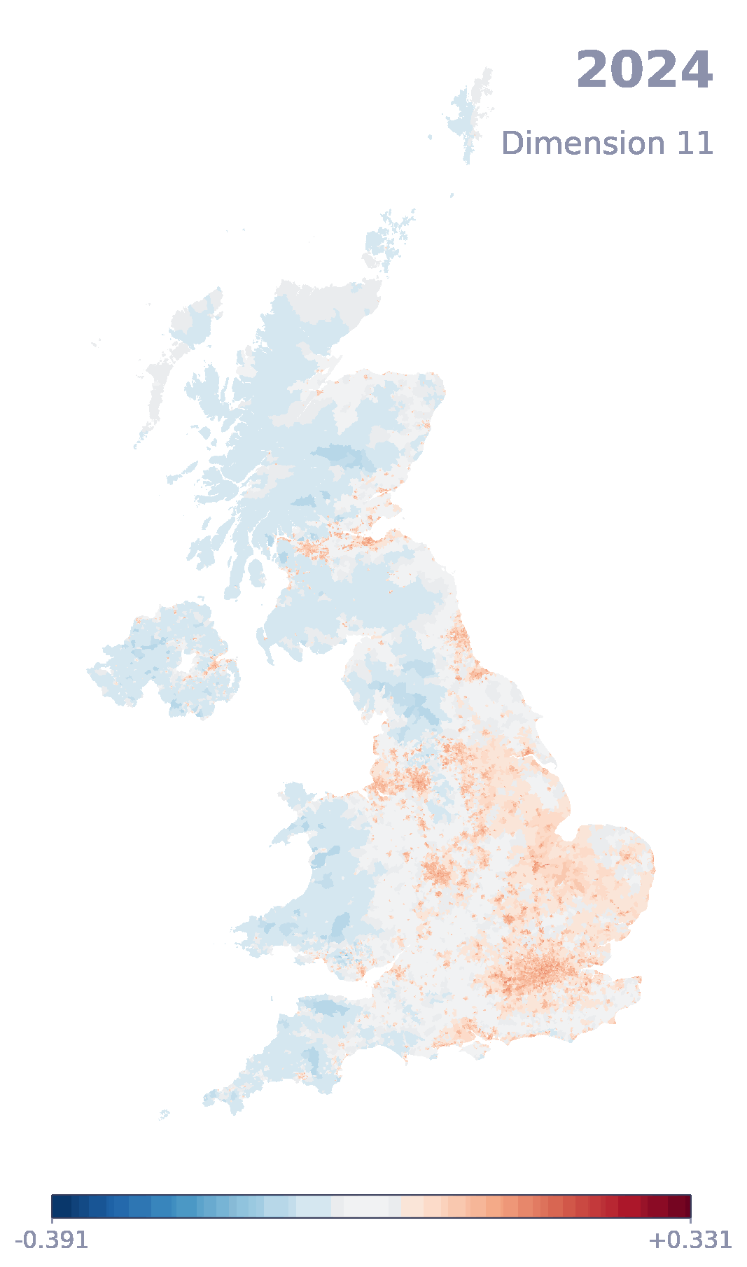
Happy release day to those who celebrate!!! Today, you can access our derived product that packages Google embeddings for small areas in the UK. Embeddings are changing how we work with satellite data. With this product, we hope it’ll be even easier to access and get started to look at places. If you take them out for a spin, let us know!
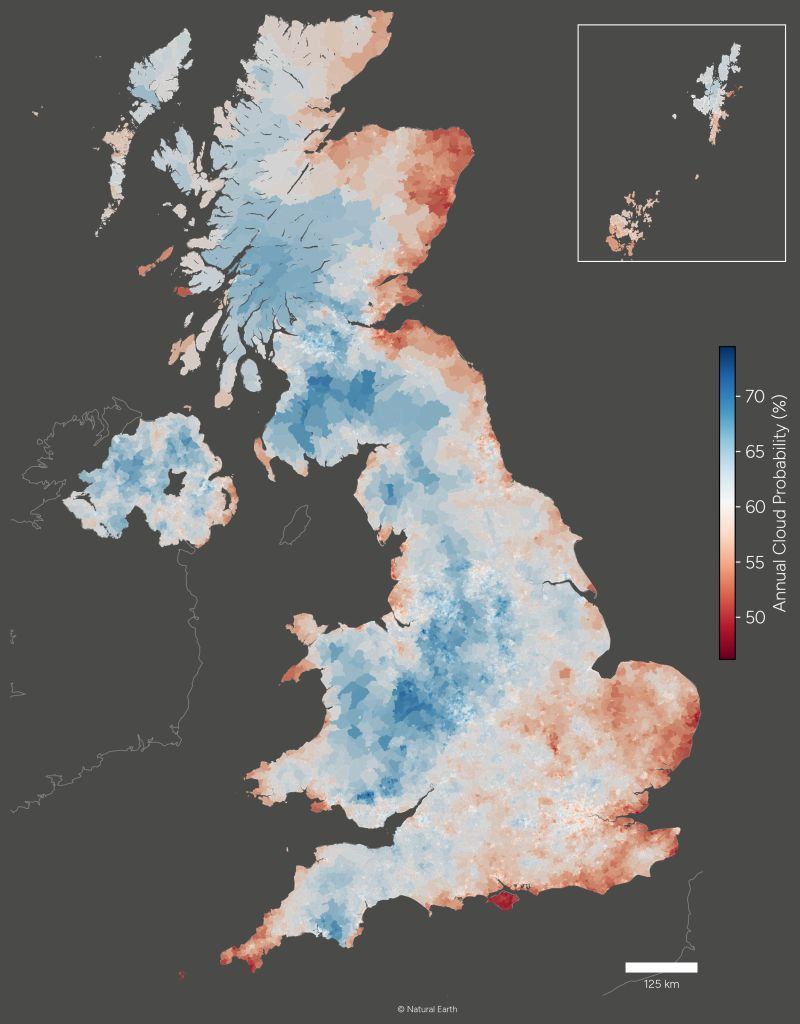
Happy data release day to those who celebrate!!! We’ve been working really hard (how hard can it be to count clouds? a lot, it turns out…) to bring you all your cloudy needs neatly packaged. If you play with SPF, we’d love to hear from you!
We’re recruiting for two PhD positions at Liverpool with the Imago team and based at the GDSL:
This project investigates how satellite-derived indicators can be co-produced with policymakers and communities to better reflect real needs and lived realities. Bridging Earth observation, participation, and policy, it aims to make satellite data more inclusive, credible, and impactful in decision-making.
Space2Health explores how satellite imagery can be transformed into meaningful measures of environmental exposures linked to health. The project relies on recent AI technologies to develop and evaluate satellite-derived indicators, examining how data choices and analytical approaches shape health-relevant evidence for research and decision-making.
Both open until April 13th, get in touch for any queries.
The GLaD Podcast recognised with AAG award
This happened, the GLaD podcast is now the “award-winning” GLaD podcast:
https://www.aag.org/2026-aag-awards-recognition/
Reproduced here for posterity:
AAG Media Achievement Award
The 2026 Media Achievement Award is presented to Drs. Daniel Arribas-Bel, Rachel Franklin and Levi Wolf, the co-creators and hosts of the Geography, Life + Data (GLaD) Podcast. This podcast is celebrated for enhancing the understanding of geography by exploring the intersection of our discipline with data science, public life, and academia—or, as their episode intro says, “geography, life, geography life, and data. Launched in 2023, the GLaD Podcast and its predecessor series have produced over 50 episodes, amassing over 8,000 downloads, over 15,000 views on YouTube, and attracting more than 5,000 listeners worldwide. The podcast is renowned for its ability to simplify complex topics—such as spatial data science and urban analytics—through an engaging and accessible conversational style. It effectively breaks down barriers for students, early-career researchers, and non-specialists. Recognized as an invaluable educational resource, it has been integrated into graduate seminars and serves as a platform to humanize leading scholars. The podcast offers candid, practical advice on academic challenges like job searching and conference navigation, fostering a supportive community. GLaD’s continued independent production underscores the creators’ commitment to bridging the gap between academic research and the wider public.
Like most things worth your time in life, we did not set out to do a podcast (the “I’m in a band” of the XXIst Century…) for the awards, but it does feel very good to be recognised, mostly by people listening to it every month, and now with this too.
Thank you, thank you, thank you to everyone who’s clicked on the Play button at some point. And Thank you, Thank you, Thank you to the kind souls who nominated us for the award. Like I’ve said elsewhere, whatever they tell you, what academics really crave is peer recognition, and this feels pretty close to it!
New episode of the one and only #GLaDpodcast. For this one, we dust off our oracles to speculate what 2026 (whatever is left of it anyway) has in store for Geography, Life, Geography Life, and Data! Come for the hot takes, stay for Polymarket-style futures contracts!
Yesterday, we (the Imago team) gave a workshop on satellite embeddings for a room with about 50 people from different corners of the UK Government. It was fantastic in every respect (with the possible exception of Github bringing down our website because it thought it was receiving a DDoS attack lol). It’s so exciting to see these ideas and technology move at the speed of light from state of the art research to Government. Anything we can do at Imago to facilitate that transfer, we’re here for that!
If you’re curious, materials are available at:
imago-sdruk.github.io/EMBED2Soc…
And if this looks interesting to your and/or your organisation, do get in touch!
🔗 Earth Embeddings: Towards AI-centric Representations of our Planet
Very very timely paper that captures the current zeitgeist in EO and AI. If nothing else, it serves as a fantastic introduction to one of the technologies that I think(/hope) will help the most bring imagery to the masses in the coming years.
Metadata
Highlights
Earth embedding vectors emb are produced by a family of embedding functions E that map continuous location inputs (i.e., longitude, latitude with optionally elevation, and time) into a d-dimensional vector space:
Figure 2: Earth embeddings provide different functions: (1) They compress high-dimensional data into a lower-dimensional vector format. (2) They fuse together different geospatial data modalities, from different types of images to text and tabular data. (3) They can interpolate to unseen spatiotemporal locations, where raw data is missing. (4) They are interoperable with other AI foundation models, such as LLMs, through aligned embedding spaces.
as explicit models, extracting embeddings from raw data (e.g. satellite imagery) associated with a location (emb ∼ Eexplicit(datalocation))
implicit models, returning embeddings from only location inputs (emb ∼ Eimplicit(location)).
Earth embeddings map places and times that share similar properties closer together in embedding space.
GeoFMs are large-scale modeling and learning frameworks, whereas Earth embeddings constitute the interoperable, location-indexed data outputs that can be stored, shared, or queried independently of the model that created them.
We posit that Earth embeddings will emerge as the dominant format of geospatial data in the AI age
ways in which users can employ Earth embeddings for prediction, conditioning, simulation, and search
Call to action: Advancing analyses and applications with Earth embeddings.
• Evaluating and benchmarking Earth embeddings
• Explainable and interpretable Earth embeddings
• Learning planetary processes with Earth embeddings
Earth Embedding Models: Explicit Feature Extraction versus Implicit Neural Representation
Challenges and opportunities for improving Earth embeddings.
• Model capacity
• Spatio-temporal heterogeneity
• Data curation and scaling
• Learning objective
The research agenda we outline is fundamentally interdisciplinary: Earth embeddings will rely on feedback from domain scientists, e.g. in ecological, geological, oceanographic, and atmospheric sciences, that incorporate Earth embeddings into their analyses and from data practitioners apply- ing Earth embeddings in their workflows and products.
A bit late to post about (though not to publish!), we have a new episode of the #GLaDpodcast out. If nothing else, be enticed by the title (the oldest profession in Geography?!?!?!); if something else, delight in Anthony Robinson’s views on maps, AI, and microwave ovens!
🎧 From Data Dump to Data Product
So many common points and arguments that really resonate here and make me more hopeful for Imago. The discussion of data as infrastructure, invisibility as success, and thinking really hard about how to make sure “it”’s not only here now, but tomorrow and the day after are points that’ll stay with me. And it’s also great to find more people who’re thinking creatively (not only from the tech side of things) to ensure the world has more collective-ness around data. Most recommended listen.
Metadata
Highlights
The way I frame it is like, the game is figuring out how to lower the cost of asking questions.
🔗 Why "Science-as-a-Service" Doesn't Work for Earth Science
Very important, if sobering, piece on the TerraWatchSpace newsletter on why “handing off to industry” is not a great idea for Earth Observation (EO) for basic science. In some ways, I see parallels with the discussion in the social sciences around how traditional sources (think decadal censuses, but also large surveys, etc.) could potentially be replaced by new sources such as mobility from phones or, for that matter, modern uses of Earth Observation. Don’t get me wrong, I am more excited than most about the potential of new data in the social sciences (imagery in particular!). We do need more data than a drop every ten years to not fly blind through everything that happens between release points (which is a lot). The bit that makes me very uneasy here is the replace, rather than complement. Without the census, satellites and phones are fairly close to useless for social scientists, and the reasons are very similar to why commercial EO needs large, public, and free programmes like Sentinel and Landsat.
Metadata
Highlights
Jared Isaacman, President Trump’s nominee for NASA Administrator has articulated a compelling vision: “NASA needs to constantly be recalibrating to do the near impossible, what no one else is doing - and the things they figured out, they hand off to industry.”
Earth Science Data Is Infrastructure, Not a Service
Infrastructure requires institutional commitment that transcends market cycles and political administrations. It requires transparency, neutrality, and guaranteed long-term access. It requires optimization for societal benefit rather than profit margins.
Just in time for a cozy listen this coming break, a new #GLaDpodcast episode! This time, we welcome the one and only Serge Rey to talk all things open, open source, and academia! Come for the code, stay for the stories of lives changed!
With all the rush last month, I forgot we released a new #GLaDpodcast episode. We finally gave in to the GeoAI craze and went straight to the source. Join us for a conversation with Krzysztof Janowicz, who’s been laying the grounds for what today is called “GeoAI” for longer than you can think of!
🔗 World Urbanization Prospects 2025
Cities are (still) a pretty cool thing…